Keeping watch over our recreational and commercial waterways
Arawhata River, Westland, New Zealand
WATERSHOT is the global first for monitoring water quality and health, with accuracy from computerized, satellite data, to high tech algorithms.
WATERSHOT is a gift Dr Andrew Taylor, Paul Brown and I can give to Earth, and is a culmination of our beliefs, experiences and determinations.
WHERE
WHAT
WATERSHOT is an innovative environmental logistics company that has developed a revolutionary package of water monitoring tools that can provide rapid sampling of water data across a complete spectrum of water sources, from remote coastlines to the most isolated rivers and lakes, quickly and cost-effectively.
WATERSHOT is an intelligent approach to water quality that is data-driven, highly directed, inquisitive and comprehensive in its commitment to learning and understanding.
WATERSHOT uses a combination of satellite-based spectral analysis and direct water sampling to help industry, communities and environmental agencies effectively monitor and identify changes in river water quality.
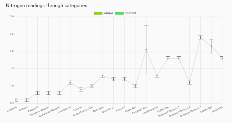
WATERSHOT portrays water quality by continuously tracking the extent of Alinity, Nitrate, E. coli, Total Suspended Solids, Turbidity and Chlorophyl-a, b, c concentrations in waterways.
WHY
HOW
Advantages
WATERSHOT can be applied to most waterways.
Improvements
WATERSHOT improves water quality monitoring by pinpointing where and when to test, resulting in improved use of limited resources. More accurate and frequent data, presented promptly, allows agencies to use the data instantly.
Management
WATERSHOT data improves the understanding of a waterway's natural order and assists management of its ecosystem.
Ethics
WATERSHOT adheres to a strict code of ethics that governs how data is collected, tested and presented. This ensures objectivity and conclusions that are firmly evidence-based.
Our Analysis
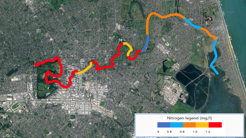
Nitrogen Analysis
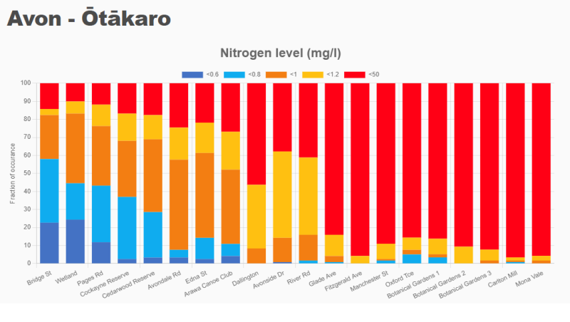
Longitudinal Studies
River Health Analysis
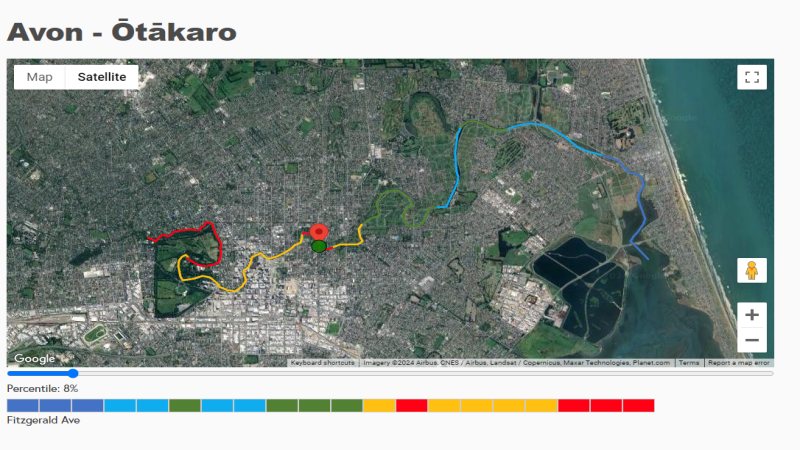
Hotspot Detection
WHO
Julie - Writer - Promoter
Andrew - Teacher - Astrophysicist
Paul - Farmer - Innovator
Andrew, Paul and I familiarly thrive in New Zealand’s backcountry in our play and in our work, as individuals, as families, and as professionals.
The three of us attainably access New Zealand’s coastlines, rural expanses, backcountry and alps, from coastlines for fishing, diving and shellfish gathering, to lakes for picnicking and sailing, to marine reserves for swimming and snorkeling, to the foothills and backcountry for hunting and tramping, and to the high peaks for snow sports and mountaineering.
In all those locations, water is the word, and clean water the imperative. Such is our pursuit, made viable by our complementary skills of stories and promotion, space science and mathematics, and agricultural innovation.
Julie Brown
Founder
WATERSHOT SATELLITE SCIENCE